
We have been working with Nottingham Geospatial Institute
(led by Jeremy Morley) over the last 2 years standing up a British National
Grid version of OpenStreetMap (OSM-GB, see: http://www.osmgb.org.uk/).
This project has captured imagination and fans well beyond our initial vision.
 The most interesting features of OSM-GB are around the
collaboration opportunities it provides. A group of councils in Surrey have
made OSM-GB their platform of choice for street naming and numbering of new
developments. The local authorities in England and Wales have long felt
aggrieved that having initiated the street naming they end up with data about
the properties they have a vested interest in managing being subject to copyright.
With OSM-GB this does not happen.
The most interesting features of OSM-GB are around the
collaboration opportunities it provides. A group of councils in Surrey have
made OSM-GB their platform of choice for street naming and numbering of new
developments. The local authorities in England and Wales have long felt
aggrieved that having initiated the street naming they end up with data about
the properties they have a vested interest in managing being subject to copyright.
With OSM-GB this does not happen.
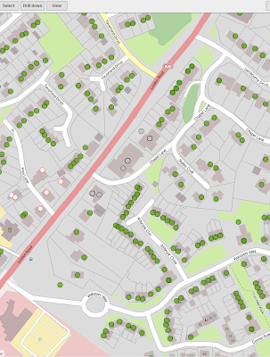
The graphic shows a new estate in Bagshot image provided by James Rutter). The whole community then has access to this mapping data even before the stuff has been finished being built! Displayed over the top is waste collection points data. The environmental health team has access to set up the new waste collection points now (these new properties are not available on any other map), so they can start planning wheely-bin deliveries.
Additionally the planners like having access to this data as there are planning enquiries as residents are in the process of moving in. The next step in this process is to go beyond the simple tag referencing in OSM and introduce master data management based on URIs. This will give the opportunity to bring in other datasets into the conflation process – such as Geonames and the data that Ordnance Survey has made available through the open data initiative being driven by data.gov.uk, such as boundaries. There is no point in conflating for the sake of being able to say this data is better than that – all data is costly to collect and maintain and the maintenance function is something that the UN GGIM (see section 2.2.3 at: http://ggim.un.org/2nd%20Session/Future%20Trends%20Background%20Document.pdf) report highlights as being of major significance.
The 1Spatial role has been to provide automated tools that
find errors and report them to the community. With our commercial customers we
would fix these errors (digitising errors, buildings in roads etc.)
automatically. In the community we feel unable to do this and didn’t want an
OSM-GB that was different from the main OSM database. At a recent project
review attended by around a dozen people, including Muki Haklay we had some
interesting feedback. This feedback is
summarised in the table below:
|
Topic
|
Result
|
|
Will automated business rules improve quality?
|
Yes
|
|
Will formal QA processes increase the confidence in the product?
|
No
|
|
Will confidence increase the contribution and maintenance of the
product?
|
No clear result
|
|
Will proactive messages of the need to update increase the community
refresh activity?
|
Not yet examined
|
|
Are there benefits from conflating with OS free products e.g.
VectorMapDistrict
|
Complementary, but see discussion below
|
 The most interesting features of OSM-GB are around the
collaboration opportunities it provides. A group of councils in Surrey have
made OSM-GB their platform of choice for street naming and numbering of new
developments. The local authorities in England and Wales have long felt
aggrieved that having initiated the street naming they end up with data about
the properties they have a vested interest in managing being subject to copyright.
With OSM-GB this does not happen.
The most interesting features of OSM-GB are around the
collaboration opportunities it provides. A group of councils in Surrey have
made OSM-GB their platform of choice for street naming and numbering of new
developments. The local authorities in England and Wales have long felt
aggrieved that having initiated the street naming they end up with data about
the properties they have a vested interest in managing being subject to copyright.
With OSM-GB this does not happen. The graphic shows a new estate in Bagshot image provided by James Rutter). The whole community then has access to this mapping data even before the stuff has been finished being built! Displayed over the top is waste collection points data. The environmental health team has access to set up the new waste collection points now (these new properties are not available on any other map), so they can start planning wheely-bin deliveries.
Additionally the planners like having access to this data as there are planning enquiries as residents are in the process of moving in. The next step in this process is to go beyond the simple tag referencing in OSM and introduce master data management based on URIs. This will give the opportunity to bring in other datasets into the conflation process – such as Geonames and the data that Ordnance Survey has made available through the open data initiative being driven by data.gov.uk, such as boundaries. There is no point in conflating for the sake of being able to say this data is better than that – all data is costly to collect and maintain and the maintenance function is something that the UN GGIM (see section 2.2.3 at: http://ggim.un.org/2nd%20Session/Future%20Trends%20Background%20Document.pdf) report highlights as being of major significance.
So there still remains much to do and 1Spatial will be at
SOTM (see: http://2013.stateofthemap.org/
in Birmingham, supporting Jeremy Morley as he discusses the project and
potential next steps.