

For those of you that attended this year’s Esri
International User Conference, you may
already be familiar with this character!
For those of you that didn’t get to the event …let me
explain! This is Socium Bear and he, along with all his brothers and sisters, joined us on the 1Spatial stand to help promote the new business applications that will be launched on the 1Spatial Cloud Platform in the coming months. These will integrate with and extend the capabilities of Esri’s ArcGIS Online, offering users apps for data validation, correction, integration, inference and generalisation.
Lucky event attendees, who adopted one of our small bears, were encouraged to join in our fun campaign and download the free Esri ArcGIS app so that they could add photos of their bear to our map and also put a pin in their home location so that we could see where in the world the bears travelled to. This created a lot of fun on the stand for attendees to the event but we are also really delighted to see that the world map is already starting to see an invasion of the bears being tagged in their new home locations.
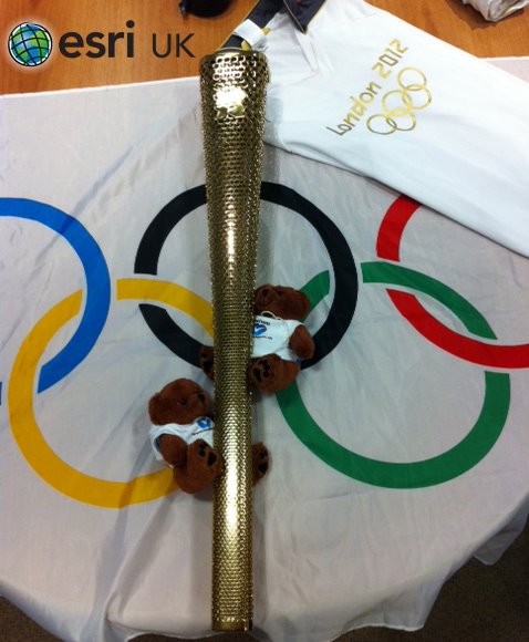 So far bears have touched down in Canada, Australia, Poland,
Germany, Italy, Spain and the UK. There is even a photo posted by Esri
themselves of two of the bears with the Olympic Torch near London in the
UK! There are also lots of photos across the United States and a
number of them were posted in San Diego during the event. One bear even took a
trip up to Hollywood after the conference finished as there are photos of him
hanging out with the stars!If you attended the event and have one of the bears, you can
still get involved and post your photos or home location. Full instructions are
on the website along with the map that shows where in the world the bears have
already appeared http://www.socium.co.uk/sociumbear/
So far bears have touched down in Canada, Australia, Poland,
Germany, Italy, Spain and the UK. There is even a photo posted by Esri
themselves of two of the bears with the Olympic Torch near London in the
UK! There are also lots of photos across the United States and a
number of them were posted in San Diego during the event. One bear even took a
trip up to Hollywood after the conference finished as there are photos of him
hanging out with the stars!If you attended the event and have one of the bears, you can
still get involved and post your photos or home location. Full instructions are
on the website along with the map that shows where in the world the bears have
already appeared http://www.socium.co.uk/sociumbear/